Neng Gao An Dong Jun & Qilai Nanhua Route D3 Waypoint
27 Nov 2025 7 waypoints 10 photos 8.69 km

D3 Itinerary
Today's route is longer and has some collapsed terrain — start early to avoid getting back to the hut in the dark.
Nenggao South Peak
Leaving Dalu Pond, head for Nenggao South Peak, the highest point of this Nenggao-Anton Jun section. Although it's only about 350m of climbing from Dalu Pond, in between there are several false peaks with ups and downs, and some sections of trail are narrow and steep, so slow down, keep your heart rate in check, and keep moving steadily. About 2.6K from Dalu Pond, you reach the Nenggao South Peak junction; you don't need to switch to a summit pack here — another 100m gets you to the Nenggao South Peak Triangulation Point.
Back at the Nenggao South Peak junction, start descending toward the South Peak South Saddle Campground; along the way a weather front moved in and it started drizzling, with conditions getting worse. About 1K brings you to the South Peak South Saddle Campground; according to the offline app data I was using, continuing to descend southeast leads to a water source, but I didn't go check it due to the bad weather.
After a short rest at the South Peak South Saddle Campground, continue on to the Peak 3159 South Saddle Campground at 1.5K. From here on, with the wind and rain picking up, I didn't strictly follow the trail — the feeling was more like going wherever the wind and rain were lighter, staying on the leeward side as much as possible. In better weather, hikers who stick to the trail can avoid some unnecessary detours.
Guangtou Mountain
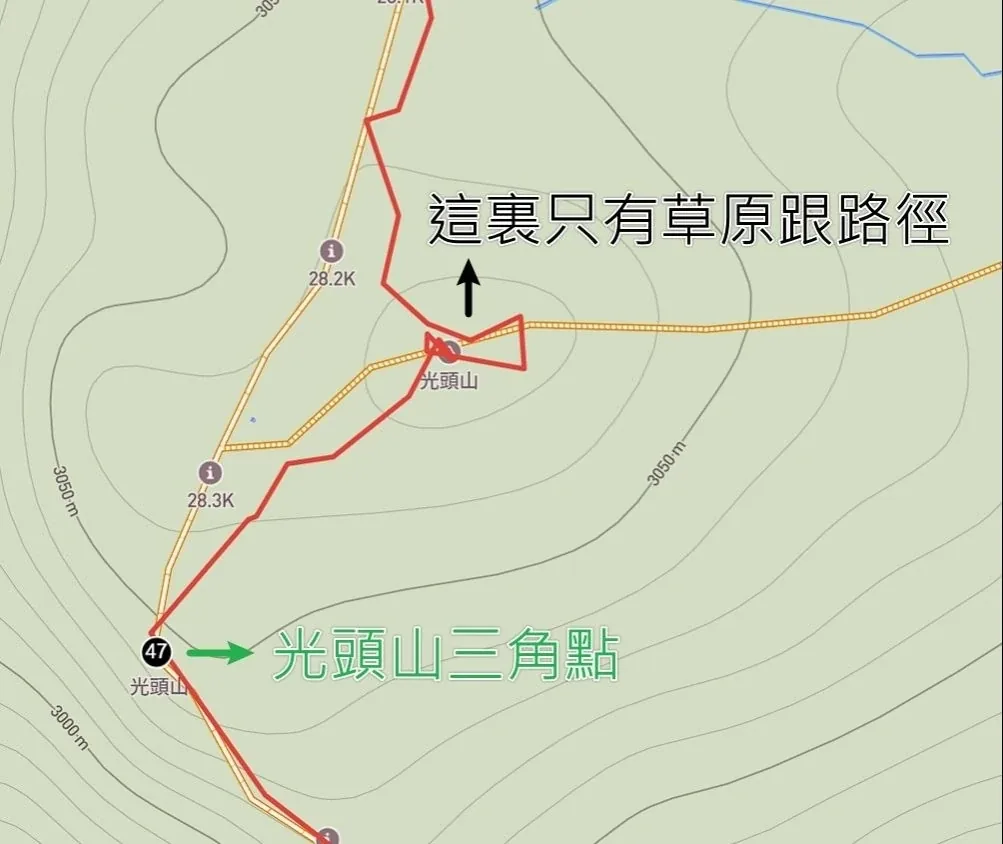
The map data in the app I was using, as of my hike on 2025/11/27, showed two possible peaks for Guangtou Mountain. The one to the northeast turned out, in reality, to be nothing but meadow and trail — the real Guangtou Mountain is at the southwest location, my Waypoint 47. Please pay attention to this so you don't waste time and energy wandering around the area, especially in the wind and rain of late autumn — the longer you stay on an exposed summit, the greater the risk of hypothermia, so be especially careful. I reported this map data issue to the app's support team after getting off the mountain. Below is a screenshot of the map data at the time, with both spots labeled 'Guangtou Mountain.'

Less than 400m from the Guangtou Mountain Triangulation Point brings you to the Guangtou Mountain landslide wall, a vertical, fully exposed section — before descending, make sure your pack's weight is balanced and won't shift, stow your trekking poles, put on your gloves, and climb down the rope. It's not over once you're down the landslide — take out the trekking poles you just put away, because you're about to face a whole stretch of collapsed scree. Keep your weight from leaning forward, take many small steps instead of a few big ones, and make sure your trekking pole is planted securely before moving your foot; keep going and you'll get back onto the forest road heading down toward Baishi Pond.
Although it's only 1.5K from the Guangtou Mountain Triangulation Point to Baishi Pond, between the careful pace through the landslide, the narrow and rugged forest road, and the wind and rain, it took me 80 minutes to reach Baishi Pond. I'd suggest finding a spot sheltered from the wind to camp here; for water, draw from the largest pond at Baishi Pond, which is cleaner — since it's not running water, filter and boil it before drinking.
Starting at Baishi Pond, there are large herds of sika deer — they don't wait for dark to come out; as soon as they sense more people around, they start appearing one by one, watching for an opportunity. While enjoying the deer, remember to protect your gear, and don't feed or harm the wildlife.
Trail Log

43 Turn left, 0.1k to the summit
3,381 m2,784↓4 min 60 m

44 Nenggao South Peak Triangulation Point
3,381 m2,784↓1 h 34 min 960 m ↓380 m

45 South Peak South Saddle Campground
3,381 m2,784↓1 h 38 min 1.68 km ↑196 m ↓120 m

46 Peak 3159 South Saddle Campground
3,381 m2,784↓50 min 1.62 km ↑110 m ↓79 m


47 Guangtou Mountain Triangulation PointMentioned in text
3,381 m2,784↓1 h 14 min 1.42 km ↑18 m ↓333 m

48 Sika deer bones
3,381 m2,784↓6 min 190 m ↑11 m


49 Baishi Pond
3,381 m2,784
Start of record05:20 3029 m 0 km Dalu Pond Campground
↓2 h 55 min 2.76 km ↑436 m ↓91 m


End of record13:42 2798 m 8.69 km Baishi Pond
← Back to D3 card